Forecasts Now Point to Tighter Windows to Plant This Week
USFR- From the Farm Forecast with Eric Snodgrass
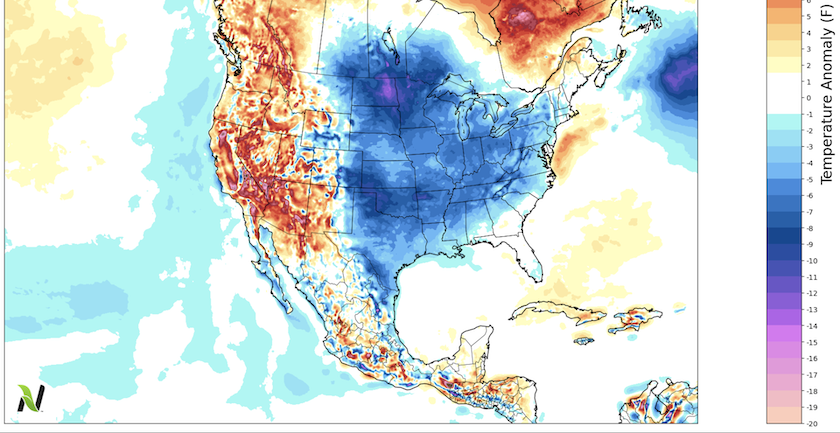
Freezing temperatures swept across the western Corn Belt over the weekend, and as the calendar will soon flip to May, one agricultural meteorologist thinks the cooler weather pattern will park itself further east, possibly slowing planting progress this week.
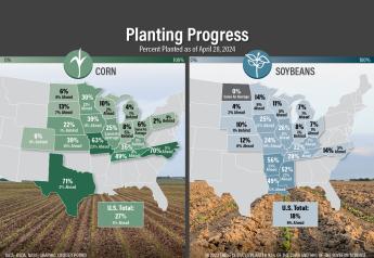
The western Corn Belt continues to lead in planting progress. Local reports show more farmers across Missouri and Kansas even finished planting corn last week. However, Eric Snodgrass, Science Fellow and Principal Atmospheric Scientist for Nutrien Ag Solutions, forecasts weather issues will create tighter planting windows this week.
“Well, unfortunately, over the western part of the United States, they're going to be seeing some warmer conditions, which means we're going to push a lot of cooler air across the Corn Belt, making it all the way to the East, as we try to finish this month of April,” says Snodgrass, who also posts a weekly show on YouTube. “That means all we got this April was that nice, big warm-up right in the middle of it. It's been bookended with colder weather. So unfortunately, we're going to be seeing a less-than-ideal kind of heat accumulation here over the finish to this month."
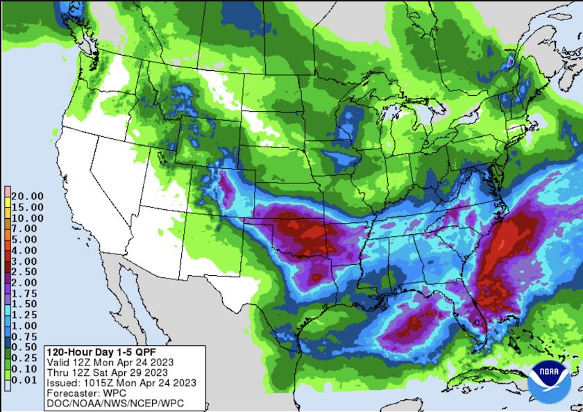
Not only will parts of the Corn Belt see a cooler weather pattern set in, but parts of the parched Plains also will see higher chances of rains the next couple of weeks.
“This is going to be something we're going to watch very, very carefully because of the extensive drought in that area,” says Snodgrass. “So, we have to kind of balance it out. We need the moisture in those areas. We need the moisture in the western Corn Belt, but it is slowing down some of this early-season fieldwork.”
Even with the higher chances of rain in the coming weeks for parts of Kansas, Oklahoma and Texas, Snodgrass warns it may not be enough to battle the drought completely. He says it will help with the planting of summer crops, but the area is still expected to remain in drought through the end of July.
“The trouble is that some of the drought that is right now anchored in Kansas and Oklahoma, Colorado and Texas, it is rivaling the drought of ‘11 and ‘12. It's rivaling the 1950s, it's rivaling the 1930s in terms of how dry it's been since late last summer. So, to undo a drought that is so intense and that long and lasting, it just takes a tremendous amount of effort,” he says.
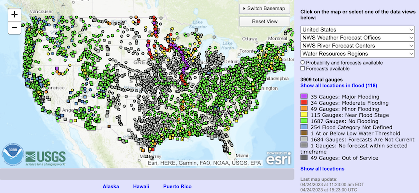
Wetter weather continues to be an issue for the northern tier of states. Flooding is already taking place in some areas, with forecasts pointing to additional flooding possible. The latest NOAA river forecast indicates 118 river gauges show minor to major flooding already occurring across the U.S. An additional 115 locations are near flood stage.
“Now, that new snow that just came in, even after all that melts, it'll start to increase that flood threat again,” Snodgrass explains. “What we're now going to be watching is the race to get the soil temperatures up. And with so much cooler air hanging around in the Northern Plains to finish the month of April, that's really going to put a squeeze on May heat.”
He says the U.S. is waiting on a big ridge to sit over the middle part of the Northern Plains and bring heat and drier weather. He says, unfortunately, the indications a warmup similar to what occurred in 2018 isn’t in the cards this year.
“I remember this, in ‘18 it was a cold April and warm May. I don't necessarily see those ingredients coming together right now,” says Snodgrass. “But the atmosphere is always full of surprises. If we start to see deep, deep troughs of cold air just off the West Coast, we've got better chances of bringing in a big ridge in the mid part of the country and blowing these planting windows wide open and getting a crop established.”
Longer-term, Snodgrass says the weather models are suggesting a return of El Niño this summer. He says if that's the case, it could support favorable crop growing conditions during the summer months.
“Since 1970, we've had 17 El Niño summers and 14 of them had trendline yields slightly above that. This means we generally think of El Niño summers of having a more juicy atmosphere, or more stuff for thunderstorms, so we'll keep a close eye on it,” he says.
Currently, Snodgrass says the likelihood of it becoming a full-fledged El Niño this summer is pegged at about 75%.
Read More:
As El Niño Makes Its Grand Return, Here's What It Tells Us About Summer Weather and Corn Yields