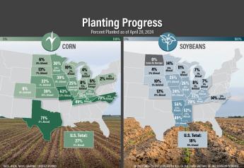
From Flooding To Frost, Latest Weather Forecast Signals Slowdown in Planting Progress This Week
USFR-From the Farm Forecast 4/15/23
From the potential for more temperatures causing frost and freezes later this week, to additional moisture bringing increased chances for flooding in the upper Midwest, the forecast for the remainder of April could hold a few more surprises and potentially slow planting progress.
After a massive warmup hit areas of the country last week, snow returned to the upper Midwest over the weekend and through Monday. Last week’s major warmup helped the deep snowpack in areas of the Dakotas and Minnesota finally melt, but it’s also creating increased flood risks for the Red River Valley and northern Mississippi River.
“What snow we had on the ground, the moisture equivalent was running from about four to eight inches with some spots up to 10 inches,” says Drew Lerner of World Weather, Inc. “So, we've put that much moisture on top of the ground in these last few days. And we'll continue to do so, and then you add another inch of rain on top of that, and you have a really interesting scenario.”
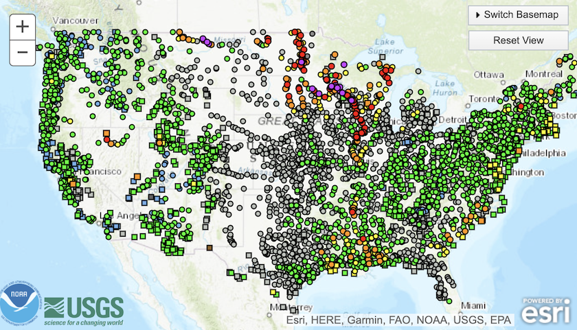
National Oceanic and Atmospheric Administration’s (NOAA) water level map shows 7 river gauges are at major flood stage, while 29 show moderate flood levels. 101 river gauges are at minor flood stage and 170 are near flood stage.
Wetter Bias Returning to the North
The most severe flooding levels are in the Red River Valley, northern Mississippi River, as well as the lower Mississippi River.
Lerner says he knows there’s still plenty of time to get spring crops planted, but he is concerned about the possibility of a wetter bias returning upper Midwest and Plains later this month and into may.
“I am concerned that we may have some prevent plant, it's still a little early,” says Lerner. “If we get back into the 90s like we were last week in South Dakota, we can make a huge difference in a short period of time. But I think that's pretty much a big reach.
Planting Problems Farther South
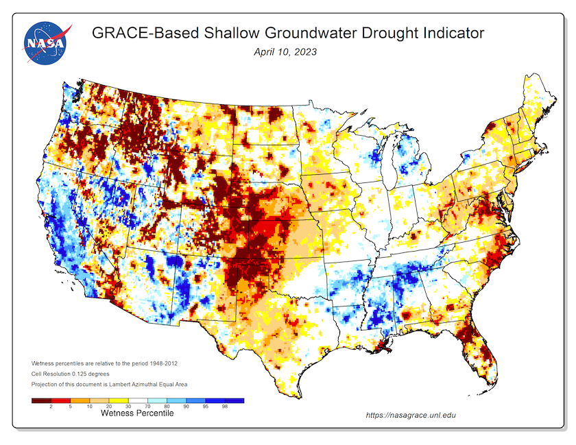
Another area dealing with wet weather is the Delta and mid-South. NOAA’s map shows how saturated things have been, with river levels already at major flood stage in some cases. The soil moisture map that shows shallow groundwater levels also shows you how wet areas of the South have been this spring.
Farmers in the area are on a tight timeline to get crops planted. If crops aren’t in by mid to late May, crop yields can be majorly impacted by intense summer heat.
As farmers in those areas work to get the crops planted, Lerner says he has some good news for farmers there.
“The southeastern states should see dry or biased weather because we'll have a little ridge of high pressure building in there in the last days of April and more likely in May, and it will eventually expand northward. And then shift to the west,” says Lerner. “So, for a few weeks, or at least a couple good solid weeks, we ought to have much drier conditions, but we've got to get through some more rain before that happens, and we're already pretty late in a lot of areas there, and it could get a lot more serious with the additional moisture coming up.”
Risk of Another Frost and Freeze Event This Week
Must of the U.S. saw a blast of colder weather reenter the picture after a major warmup last week. And while wheat growers are assessing if the cold temperatures did any damage to their crops, Lerner says he's more concerned about a second wave of cold weather that could hit later this week.
C Il frost advisory tonight. Mostly around 34F for lows from NWS. pic.twitter.com/rBuuPI6z3D — Allen Motew (@QTweather) April 17, 2023
He says similar weather pattern hit in mid-October, mid-December and Mid-February. Each time, the pattern looked like an innocent cooler mass, but then as it got closer to time, it became much broader—and much colder.
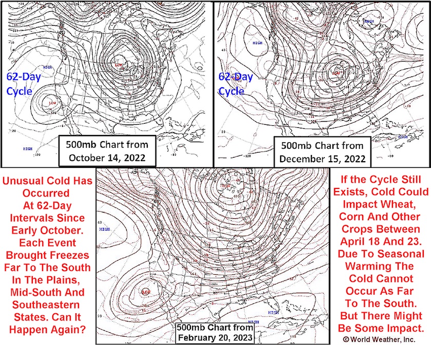
"Now, don't get ahead of me here. I'm not suggesting we're going to see freezes in Louisiana,” says Lerner. “But we could see some significant coolness. I believe, though, the strongly negative Pacific Decadal Oscillation (PDO) that we have right now is going to fight against the cold. So, we should limit it to the northern and central parts of the Midwest, is what I’m saying right now. And it's not ready to be set in stone. But they may be down to northern Missouri and central Illinois, maybe even southern Indiana and southern Ohio.”
Another blast of cold air a week from now. Potential freeze line then. pic.twitter.com/TKQb570sJ9 — Allen Motew (@QTweather) April 16, 2023