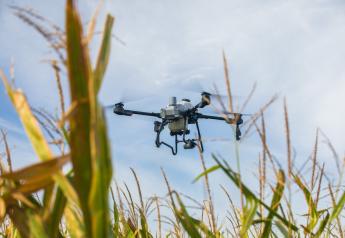
On-site Image Stitching Free For AgVault Users

Sentera and the OpenDroneMap project collaborate to bring free, local image stitching to AgVault users.
AgVault subscribers will have the option to locally produce high-quality NDVI, NDRE, and RGB mosaics without any additional costs or subscriptions. Sentera will open a private beta for this feature in October, a public beta mid-winter, and plans to release the free-stitching product in time for the 2018 North American growing season. Sentera will continue to offer its commercial cloud-based stitching products for multispectral data, large datasets, or customers who simply prefer not to use local stitching.
OpenDroneMap creates fully-stitched image mosaics using data from Sentera's most popular sensors, including visual-band, normalized difference vegetation index (NDVI), and normalized difference red edge (NDRE) imagery.
The process is silently and automatically managed from within the AgVault Desktop application. All mosaics created locally with OpenDroneMap are free. OpenDroneMap integration for AgVault will be available in October to select partners through a private beta.
For more information about the private beta click here.
For more information about OpenDroneMap click here.