Analytics To Look At 50,000 Acres In 30 Minutes
As an aerial imagery analytics company, IntelinAir is working to equip trusted advisors with tools to help farmers make better decisions faster.
The company’s AgMRI system is informed by 13 in-season high resolution images as well as layers including: weather, soil data, as-applied maps and more. Its machine learning is applied to identify performance issues and alert users to areas and fields that need to be addressed.
“This intelligence allows for an agronomist to look at 50,000 acres in 30 minutes and then appropriately address a prioritized list of fields in need of immediate attention,” says Josh Thornsbrough, IntelinAir vice president of sales and marketing.
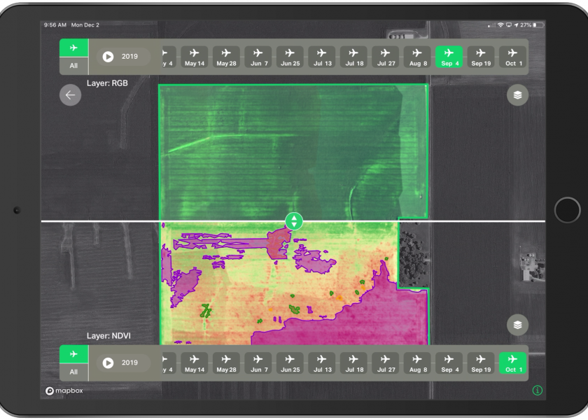
The high-resolution images displayed in the AgMRI platform provide a row by row and plant by plant view. The newest feature to AgMRI is Compare View, which allows for side-by-side comparisons of field images gathered through the season.
“You can scroll through the progression of the season and pinpoint exactly when the issue occurred,” Thornsbrough says. “For example, it’s one thing to know you have an emergence problem, but it’s another thing to know why. We’ve been able to use our tools to give population estimates and make smarter, faster replant decisions.”
He also details how this tool can help evaluate the performance of management decisions through the season. One example given is how the platform identified a row stressed due to lack of nitrogen in an early season application, a rescue application was made, and the crop response was measured.
Scouting photos can be added to the system by any authorized user.
“The automated crop intelligence is changing the way farmers and retailers communicate.” Thornsbrough says. “We talk about how our product is helping illustrate the benefits of man plus machine.”
Another example given by Thornsbrough is a field struck by a wind event. From the road, the field appeared fine, however the aerial images identified stressed corn.
“Without being able to identify that there was an issue and then go out and scout the field, the farmer and their seedsman would not have been able to respond in such a timely manner,” he says.
And he says the IntelinAir team is aiming to help retailers gain a competitive advantage.
“IntelinAir can help retailers go from being product and service oriented to become a business partner because we can help bring information farmers don’t already know and can’t get anywhere else,” he says.
The company is focusing on a geographic area in Illinois between Bloomington, Champaign and Springfield where the products has been used on 5 million acres. It also has plans for future expansion.


