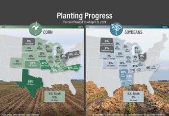
FJ AgTech Expo: Aerial Imaging Getting Easier

The concept of scouting farm fields is taking to the sky as new technology makes it easier than ever to get a bird’s eye view of the fields below. At Farm Journal’s AgTech Expo two aerial experts, Al Eisaian, CEO and co-founder of IntelinAir and AgMRI, joined Paul Miller, chief science officer at Agrible, to discuss the future of aerial imagery.
“Whether you like it or not this technology is coming,” says Eisaian. “I look at it as the fourth revolution of agriculture.”
He says tractors, chemistry and bioengineering were the first three revolutions in this industry. He believes data and aerial imagery will be the next big change and it's being driven by falling costs.
“If you look aerial imagery two or three years ago, people would charge you $2 to $4 per acre per flight just to get the imagery,” says Eisaian. “Then you would have to sit there and try to figure out what the image is telling you.”
On every flight, his company tries to capture four different pictures of the field: red, green, blue (RGB); near-infrared; normalized difference vegetation index (NDVI); and thermal. Agrible believes getting a picture in the visible light spectrum of RGB is better than nothing, and it’s less expensive.
Both businesses believe the issue lies in doing something with that information.
“When farmers say they are interested in imagery, I tell them to be interested if they are a smaller farmer and can look at 30 to 40 pictures,” says Eisaian. “If you are bigger, then that it’s too hard for the human eye to find all of the problems.”
Today, companies are finding ways to do that analysis for farmers with computers and algorithms. That processing saves hours of time in the office staring at a screen.
“We are a predictive forecasting company and we use the [pictures] and information coming into to our feeds and model what’s happening with the crop so that we can predict how those [crop] stresses might set in even before they show up in imagery,” says Miller. “We can get you a couple of weeks ahead in terms of [crop] issues and where you might be interested in spending your dollars to help fix the problem.”
“Our analytics reveals a lot of different problems,” says Eisaian. “We see things like early emergence problems, weed problems and even equipment issues like compaction.”
Capturing those aerial images are getting easier as well thanks to new lower-cost drones.
“You get a view of your crop like you’ve never seen before with a resolution that you’ve never seen before,” says Miller. “I can fly thousands of acres in my car in a single day.”
Miller says it’s not uncommon for a farmer to fly over a 100-acre field in less than 30 minutes.
“Imagine being able to take this [imagery] and share it,” says Miller. “That picture can then be used for things like planning spraying missions or management which makes it incredibly valuable.”
Beyond cheaper and more capable drones, investment continues to pour into commercials satellites although limitations remain.
“The best satellite imagery available today is roughly 50 centimeters per pixel or roughly 22 inches,” says Eisaian. “The other issue is that at any given time, roughly 60 percent of the earth’s atmosphere is covered in clouds making imagery impossible.”
Problems that may be overcome as access goes up and costs come down, but new competition is on the way from high flying drones.
“Airplane-based imagery will probably be extinct in the next five years,” says Eisaian. “High flying drones are capable of persistently capturing high-resolution information.”
Both experts say handling these high-resolution images and the data that’s produced, is likely to be the biggest changes on the horizon.
“In one season, we captured 140 terabytes of data,” says Eisaian. “Processing costs are dropping because of companies like Amazon, Google and now with quantum computers, it’s going to get even cheaper.”
Miller says eventually the images will be processed on the drone or airplane.
“In the future, we’ll likely see graphics processing units helping to crunch the images in real time like what we see now in computers,” says Miller. “We’re just not there yet and mostly because we’re limited in what the drone manufacturers allow us to do.”
Regardless of how the future stacks up, Miller believes collecting and processing aerial images will be a tool to help growers make decisions about their crops and marketing in a more efficient way.
“I can tell you, agriculture in five years will be radically different than what it is today,” says Eisaian. “The water is getting warm and it's getting warmer, so don’t be afraid to try it on your farm.”